Customize
Show Japan GSI Map in Menu Area (Japan Only)
Summary
Show a map at the menu position using the data of the Geospatial Information Authority of Japan.
How to use
Geospatial data from the Geospatial Information Authority of Japan may require an application to the government depending on the purpose of use. Please check on the Geospatial Information Authority of Japan’s website whether an application is required.
Unlike the “[SShow Map in Header[” action using Google Maps, there is no need to obtain an API key.
Parameters
Set Place, Latitude/Longitude, Zoom, and Map Height in pixel.
Place
Specify the location to display the map.
- Above Menu in Detail Page: The map will be displayed in the designated position shown in the figure below when viewing either the record detail, edit record, or new record page. On the print page, while there is no error, the map will not be displayed. However, showing the map on other pages will result in an error.
- Under Menu in List Page: The map will be displayed in the designated position shown in the figure below when viewing the record list page. However, showing the map on other pages will result in an error.
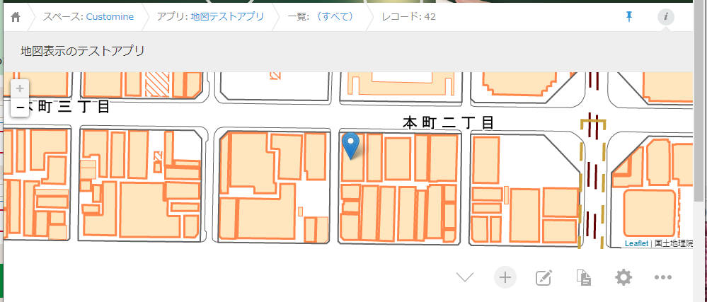
Under Menu in List Page
Latitude/Longitude
Specify latitude and longitude separated by a comma.
34.687315, 135.526201
Unlike the “[Show Map in Header[” action using Google Maps, it cannot be specified by address.
Zoom
Enter the zoom level.
Please use the following as a guideline:
- 1: World
- 5: continent
- 10: City
- 15: Street
- 20: Building
Map Height in pixel
Specify the height of the map to be displayed in pixels.
The width cannot be specified. The entire width is used.
Restrictions
-
The “Above Menu in Detail Page” option is not available on the record list page.
-
The “Under Menu in List Page” option is only available on the record list page.
-
The “Right of Menu in List Page” option does not exist.
-
The mobile view only supports “Under Menu in List Page.”
-
Since it is map data provided by the Geospatial Information Authority of Japan, there is no data for maps outside of Japan.
Displaying of Two or More Maps
If you execute the “Show Japan GSI Map in Menu Area” action twice with the same action number, it is considered the same map, and only one map will be displayed. In the second action, the currently displayed map position will not change, but the zoom level will return to the value specified by the action.
If you execute “Show Japan GSI Map in Menu Area” with different action numbers, each map will be displayed separately.